0 comments
Google has taken over the world. Okay, it hasn’t, but it has changed the way people everywhere interact with the world. Google maps is one of the more pervasive and convenient things the company has introduced. Smartphones are all over, and people use them to get from place to place using GPS. There are tons of different map apps in the world, but Google Maps seems to be the most used. It is convenient, accurate, up to date, and offers turn-by-turn directions with traffic alerts and route options. The question is: how do you use Google Maps?
Google Maps app is included in Android operating systems, but it is also available to download and use on Apple OS.
To start using the navigation system, open the Google Maps app on your phone or tablet. In the search bar, enter the name of the location or address you wish to go to. A list of locations matching your description will appear. Click on the one you want. In the bottom left hand corner of the screen, you will see a blue button saying Directions; click on it. You can hold the button, and directions will immediately begin using your current GPS location based on vehicular transportation methods. In this instance, you’re ready to get where you’re going.
If you tap on the Directions button, you will have more route options available to you. Enter your starting point; you can choose a destination, use your GPS location, or choose a spot on the map. In the upper right hand corner, you’ll see three dots lined up vertically; these will give you more route options such as Add stop, Set depart or arrive time, Add route to Home screen, Share directions, and Share your location.
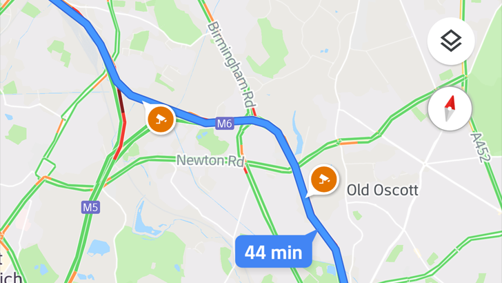
You can also choose which mode of transportation you want to use. The car symbol is for driving directions; the train is for public transit; the walking person icon is for walking directions; a bicycle is for cycling. The fastest route will be highlighted in blue. Other routes will be shown in a light grey color along with their estimated travel times. You can tap whichever route you would like to take. To begin navigation, click the arrow button. To stop navigation, hit the X in the bottom left hand corner at any time during navigation.
Traffic and other alerts will pop up on the screen. Slow downs on the route will be highlighted in orange or red. You can also see the map from your point-of-view by tapping the compass icon. You can choose to hear directions or mute directions. After starting navigation, there is a sound icon in the upper right hand corner. Tap this icon to mute or unmute. This feature will also alert you to anything like traffic, accidents, construction, or speed traps.
Google Maps has tons of features. These are the most commonly used features, and they are the most important when you first start using the app.
No comments yet. Be the first!